ProxMaP: Proximal Occupancy Map Prediction for Efficient Indoor Robot Navigation

University of Maryland, College Park
Interpolation end reference image.

Overview of the proposed approach. The training and inference flows are indicated with red and black arrows, respectively. We take the input view by moving the robot to left and right sides (CamLeft and CamRight), looking towards the region of interest. ProxMaP makes predictions using the CamCenter only, and the map obtained by combining the information from the three positions act as the ground truth.


Abstract

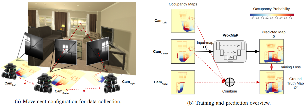
In a typical path planning pipeline for a ground robot, we build a map (e.g., an occupancy grid) of the envi- ronment as the robot moves around. While navigating indoors, a ground robot’s knowledge about the environment may be limited due to occlusions. Therefore, the map will have many as-yet-unknown regions that may need to be avoided by a con- servative planner. Instead, if a robot is able to correctly predict what its surroundings and occluded regions look like, the robot may be more efficient in navigation. In this work, we focus on predicting occupancy within the reachable distance of the robot to enable faster navigation and present a self-supervised proximity occupancy map prediction method, named ProxMaP. 
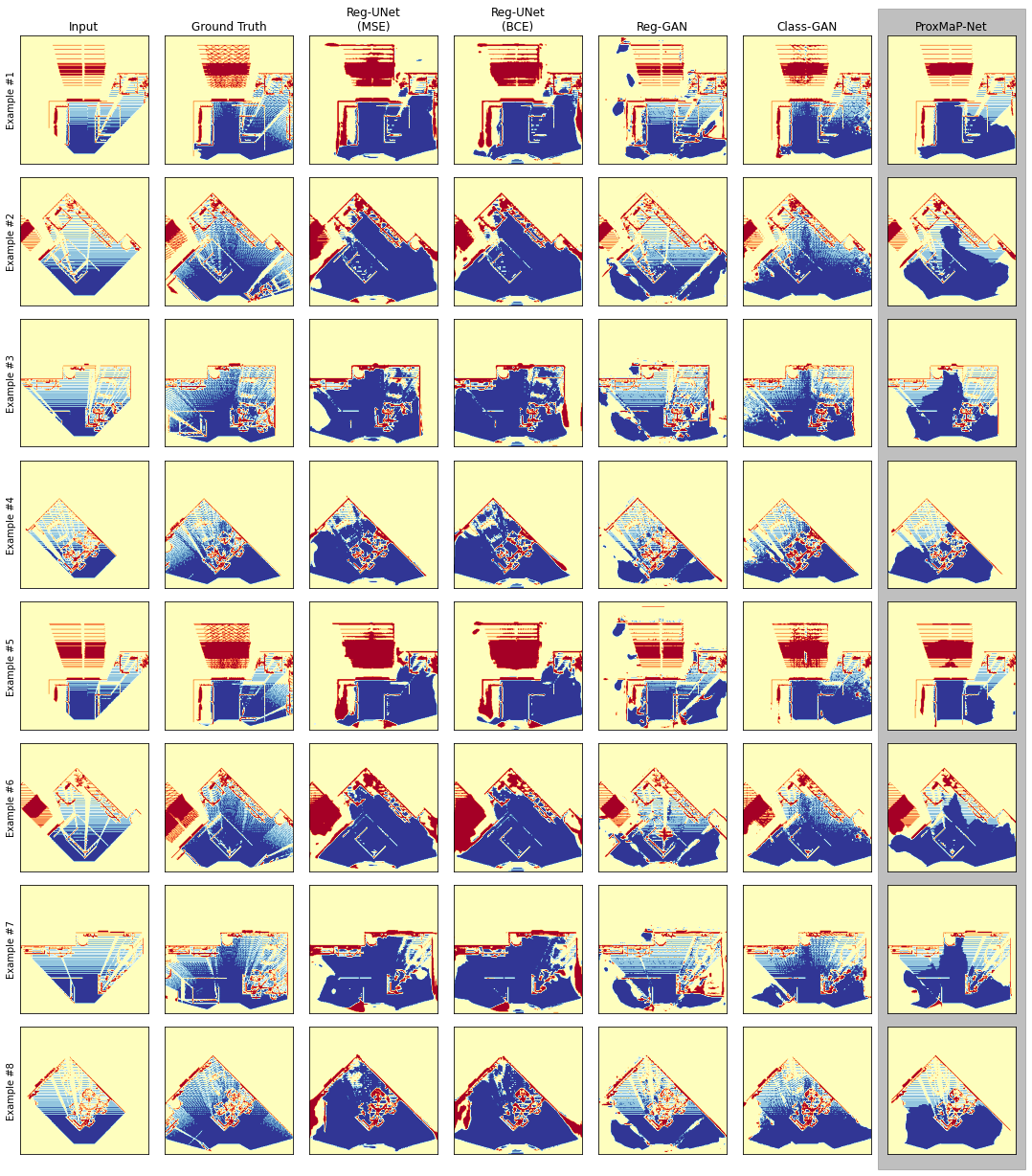
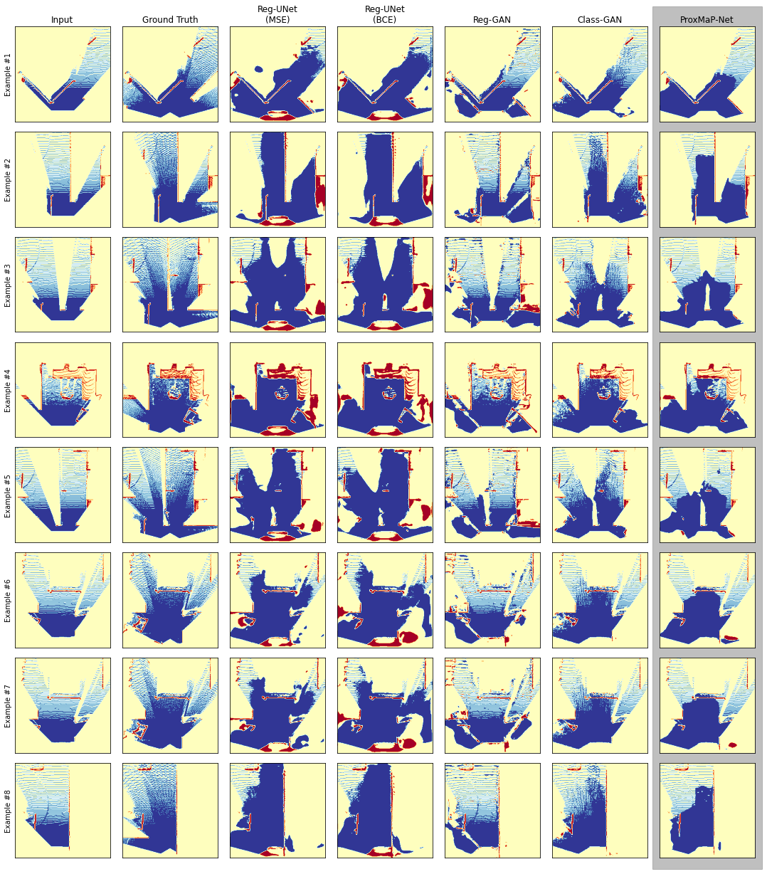
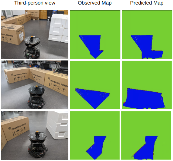
We show that ProxMaP generalizes well across realistic and real domains, improves the robot navigation efficiency in simulation by 12.40% against the traditional navigation method.


Non-Predictive Navigation with Single Sensor

Non-Predictive Navigation with Multi-Sensor Setup

Prediction-based Navigation with Single Sensor

The robot can navigate faster based on the occupancy information on the path. Single sensor setups (e.g. camera) have limited field of view and obstacles can limit the perceived information. A Multi-camera setup can add more infromation about the surroundings, but increases cost of deployment. ProxMaP predics the information about the surroundings to help the robot navigate faster using observation from a single sensor. The videos show costmaps with the observed occupied and free areas in black and green, respectively. The predicted occupied and free areas are shown in pink and blue, respectively.

Qualitative Results for Prediction

Here we show results from ProxMaP and its variations on living room data obtained from AI2THOR simulator. Abbreviations Reg and Class refer to Regression and Classification tasks, respectively. ProxMaP is a classification model.

Interpolation end reference image.

Generalizability

Below we show results from ProxMaP and its variations on living room data obtained from Habitat-Matterport3D (HM3D) simulator. Abbreviations Reg and Class refer to Regression and Classification tasks, respectively. ProxMaP is a classification model.

Interpolation end reference image.

Comparison of ProxMaP-Net and its variants against non-predictive navigation, an equivalent robot setup with 3 cameras, and another self-supervised occpancy map prediction method by Wei et al. in AI2THOR living rooms. We use Success weighted by (bornalized inverse) Completion Time (SCT) as the metric.


Method SCT
Baseline (non-predictive) 0.589
Wei et al. 0.568
Reg-UNet (MSE) 0.629
Reg-GAN 0.592
Class-GAN 0.632
ProxMaP 0.662
3-Cameras (non-predictive)     0.648


Below we comapre these methods in a more challenging situation by modifying FloorPlan227 to add more possible paths and thus emphasize decision-making. We find that ProxMap performs well compared to other predictive approaches and performs close to the from the 3-Camera setup.

Method SCT
Baseline (non-predictive) 0.615
Wei et al. 0.623
Reg-UNet (MSE) 0.571
Reg-GAN 0.573
Class-GAN 0.600
ProxMaP 0.668
3-Cameras (non-predictive)     0.690

Prediction on Real Data

Here we show prediction from ProxMaP over real data. We use a TurtleBot2 robot with Hokuyo laser scanner mounted on it. The field of view of the scanner is ;imited to 45 degrees and the data from it used to create the occupancy map. These examples show that even when only a part of the obstacles, boxese here, is visible, ProxMaP can extended in accurately and also predict the free area correctly.

Interpolation end reference image.

Related Works

Occupancy Map Inpainting for Online Robot Navigation. Minghan Wei, Daewon Lee, Volkan Isler, Daniel Lee. ICRA 2021.